
What happens when a robot’s GNSS signal drops out under a bridge, or someone has moved half the pallets in a factory since the previous shift? For most systems, the position estimate deteriorates and the machine stops being safe or productive. For ours, it is business as usual.
At the core of our approach is a technique called Normal Distributions Transform, NDT. It is a mathematical method for representing environments and enabling the alignment of 3D lidar sensor data into precise, probabilistic 3D maps. To understand it, consider something close to everyday life. Think about how you recognise your own street. You do not mentally catalogue every brick or window. You remember the shapes: the profile of the roofline, the curve of the road, the outline of the lamppost, and you automatically ignore the cars and people passing through. Our algorithm works on the same principle, except it does not need colours, textures, or text. It sees purely in geometry but unlike us humans, it uses basically everything it detects. That means it works in darkness, in fog, in falling snow, and in conditions where camera-based solutions would fail.
Rather than tracking over two millions of individual points a modern 3D lidar generates every second, our algorithm divides the surrounding space into a three-dimensional grid, an Occupancy Map. Each cell of that grid, called a voxel, compresses all the structural information within it into a single compact mathematical object: a 3D normal distribution represented as an ellipsoid. Think of a lentil, or a sugar-coated chocolate candy. Everything inside the ellipsoid is structure. Everything outside is treated as noise: sensor artefacts, reflections, falling leaves, snowflakes, and passing pedestrians. A single parameter controls how aggressively the algorithm filters these outliers, tuned to the expected environment.
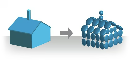
The result is twofold. First, NDT dramatically reduces the computational load compared to traditional point-by-point scan matching. Our algorithms run in real time on a standard industrial PC, with no specialised GPU required. Second, the probabilistic representation makes the system inherently robust to dynamic scenes. A forklift driving through the map, a person crossing the corridor, a shelf repositioned overnight, none of these compromise the quality of the map, because transient objects never fit the structural model.
That said, when the environment undergoes truly significant structural change, a warehouse reconfiguration, a new building on site, a major renovation, the map itself needs to be updated. Fortunately, remapping with our KARTTA software is a straightforward process, typically completed in a single pass through the updated environment.
This is why GIM Robotics’ localisation works where others fail frequently: in a harbour terminal, inside a mine shaft, under a dense forest canopy, or on a construction site in a Finnish winter storm. The environment teaches the mapping algorithm its shape once. After that, the localisation algorithm knows where the machine is, regardless of what changes around it.
NDT is a central part of what makes our localisation solution robust, but it is just one piece of a larger picture. The reason our systems perform reliably across such a wide range of environments and conditions is the way we combine 3D lidar data with various other sensor modalities such as IMUs and wheel encoders, and in some cases cameras or radars, fusing their data all together in real time. Sensor fusion is central to our expertise, and it is what turns a strong mapping solution and probabilistic localisation algorithms into a production-ready solution that handles the full complexity of the real world.
Contact us today to discover how our 3D positioning and perception solutions can transform your AGVs and AMRs into the most capable, cost-effective machines on the market.
